
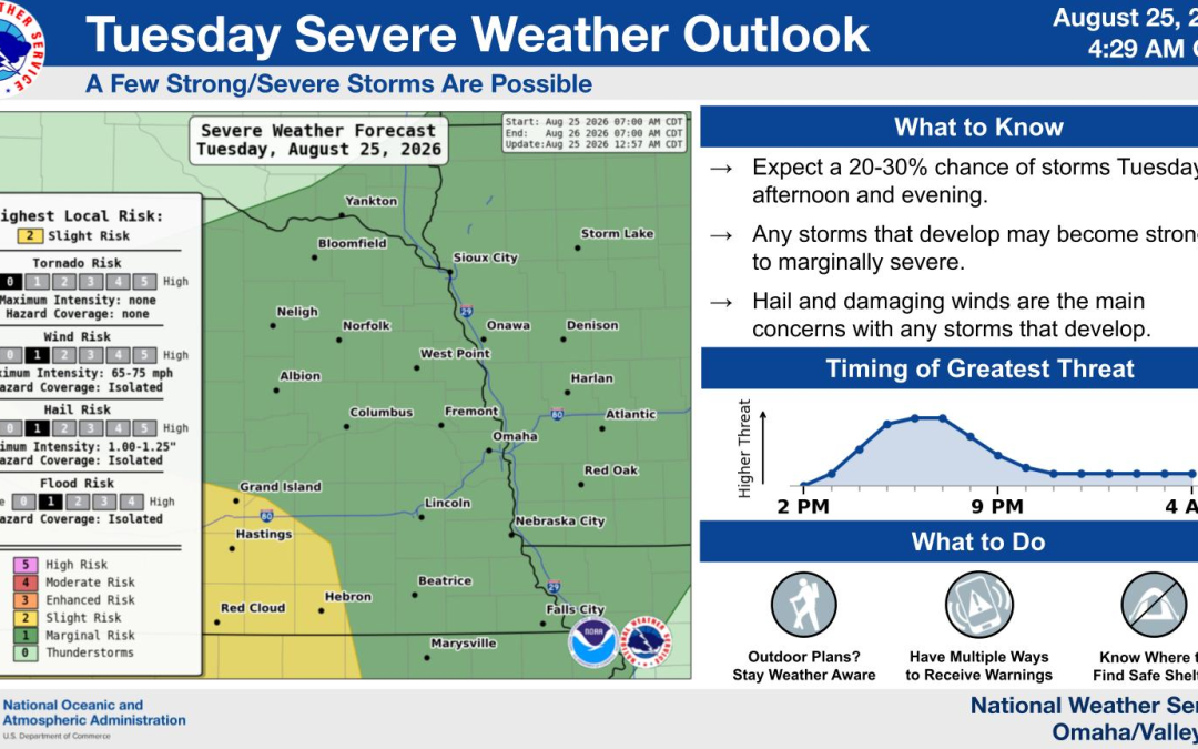
Parts of Nebraska have a 20% to 40% chance of storms Tuesday afternoon and evening. Omaha was not under a watch or warning late Tuesday morning.
Updated at 11:30 a.m. CDT on Aug. 25, 2026.
Parts of central and eastern Nebraska could see isolated thunderstorms Tuesday afternoon and evening, with large hail and damaging winds possible in the strongest storms.
The National Weather Service office in Omaha/Valley placed the probability of storms between 20% and 40% for Tuesday, Aug. 25. Forecasters said the severe-weather threat is conditional because storms may remain concentrated over central Nebraska before moving toward north-central Kansas.
Omaha and Douglas County were not under a severe thunderstorm watch or warning as of 11:30 a.m. Tuesday.
Storm chances have decreased but have not disappeared
Storm development is expected to be isolated rather than widespread. Some locations in eastern Nebraska may receive no rain, while communities farther west could have a greater chance of seeing a thunderstorm.
The highest opportunity for development will be during the afternoon and evening. Storm chances will diminish Tuesday night as the system moves away from the region.
The current setup is more limited than the strong storm threat that crossed eastern Nebraska in late July.
Large hail and damaging winds are the main hazards
Any storm that becomes severe could produce large hail and damaging wind gusts. The forecast does not specify an expected hail size or maximum wind speed for Tuesday’s storms.
The National Weather Service classifies a thunderstorm as severe when it produces hail at least 1 inch in diameter or wind gusts stronger than 58 mph. Lightning and brief heavy rain are also possible around thunderstorms, including storms that do not reach severe limits.
The latest regional outlook and forecast changes are available in the National Weather Service Omaha/Valley forecast discussion.
Omaha is not under a storm watch or warning
No severe thunderstorm watches, warnings or advisories were active for the Nebraska portion of the Omaha/Valley forecast area late Tuesday morning.
A watch would mean severe thunderstorms are possible across a broader area during a designated period. A warning would identify a more specific location where severe weather has been detected by radar or reported on the ground.
If a warning is issued, it will include the affected counties or communities, the expected hazards and an expiration time. The National Weather Service directs people inside a warned area to move into a substantial building and stay away from windows.
Omaha’s city forecast calls for partly sunny conditions Tuesday with a high near 87 degrees. Tuesday night is expected to be partly cloudy with a low near 67.
Sunshine returns Wednesday and Thursday
Storm chances will fall Tuesday evening, followed by quieter weather for the middle of the week.
Omaha is expected to have sunshine Wednesday with a high near 86 degrees. Thursday will also be sunny, with a high near 85.
Tuesday’s forecast at a glance
- Areas: Parts of central and eastern Nebraska
- Timing: Tuesday afternoon and evening
- Storm probability: 20% to 40%
- Main hazards: Large hail and damaging winds
- Omaha alert status: No watch or warning as of 11:30 a.m.
- After the storms: Drier weather Wednesday and Thursday
Forecasts and alerts can change as storms develop. Any warning issued Tuesday would identify the affected area and the time the immediate threat is expected to end.
Stay informed about what’s happening in your community. Your source for stories that inspire — visit HolaNebraska.org for news, culture and community updates across Nebraska.