
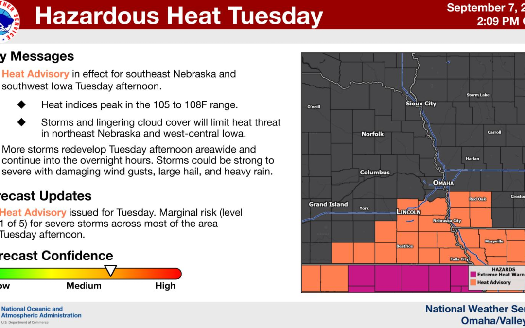
The advisory runs from 1 to 7 p.m. CDT Tuesday, Sept. 8, across Lincoln and nine other southeast Nebraska counties. Strong storms could follow during the afternoon and evening.
By Hola Nebraska
Updated Sept. 8, 2026.
LINCOLN, Nebraska — Ten southeast Nebraska counties will be under a Heat Advisory Tuesday, Sept. 8, as temperatures climb into the 90s and high humidity pushes the heat index as high as 108°F in parts of the region.
The advisory will be in effect from 1 to 7 p.m. CDT and includes Lancaster County, home to Lincoln, along with Cass, Otoe, Saline, Jefferson, Gage, Johnson, Nemaha, Pawnee and Richardson counties.
The hottest conditions are expected mainly along and south of Interstate 80.
In Lincoln, temperatures could reach 98°F, with heat index values as high as 106°F. Thunderstorm chances will increase during the second half of the afternoon and continue into Tuesday night.
The advisory includes Lincoln, Beatrice and Nebraska City
The Heat Advisory covers communities including Lincoln, Plattsmouth, Nebraska City, Crete, Wilber, Fairbury, Beatrice, Tecumseh, Auburn, Pawnee City and Falls City.
The Nebraska counties included are:
- Lancaster County
- Cass County
- Otoe County
- Saline County
- Jefferson County
- Gage County
- Johnson County
- Nemaha County
- Pawnee County
- Richardson County
Omaha and Douglas County are not included in the Heat Advisory.
High temperatures are expected to reach the mid to upper 90s across southeast Nebraska. Dew points in the low to mid-70s could push heat index values into the 104°F to 108°F range, particularly along and south of I-80.
Strong storms could bring 60 to 70 mph winds and hail
A cold front moving across eastern Nebraska Tuesday will increase thunderstorm chances during the afternoon and evening.
Some storms could strengthen quickly and produce wind gusts of 60 to 70 mph. Hail as large as approximately 1.5 inches also cannot be ruled out.
The threat could shift toward heavy rainfall Tuesday night as storms repeatedly move across areas near and south of Interstate 80.
Some locations could receive 2 to 3 inches of rain or more where multiple storms pass over the same area.
Hola Nebraska has also covered previous severe weather threats involving damaging winds, large hail and heavy rain across Nebraska.
Lincoln could drop from 98°F Tuesday to around 80°F Wednesday
Thunderstorm chances in Lincoln will increase late Tuesday afternoon, with rain and storms becoming more likely Tuesday night.
The chance of precipitation reaches 90% overnight, with general rainfall amounts of one-quarter to one-half inch possible. Higher amounts could fall inside thunderstorms.
Temperatures will fall sharply after the cold front passes.
Highs across eastern Nebraska are expected to drop into the upper 70s to low 80s Wednesday and Thursday, ending the stretch of above-normal early September heat.
Lincoln is expected to reach only around 80°F Wednesday, with some rain still possible during the morning.
Heat-related illnesses become a concern Tuesday afternoon
The combination of high temperatures and humidity can increase the risk of heat exhaustion and heat stroke, particularly during prolonged outdoor activity.
During the advisory, official safety guidance includes drinking plenty of fluids, staying in air-conditioned spaces when possible, limiting time in direct sunlight and moving strenuous outdoor activity to the cooler parts of the day.
Lightweight, loose-fitting clothing can also help reduce heat stress.
The Heat Advisory for Lincoln and the affected southeast Nebraska communities remains in effect until 7 p.m. CDT Tuesday.
After the afternoon heat, the main weather concern will shift to thunderstorms, strong wind and heavy rainfall Tuesday evening and overnight. Cooler temperatures will follow Wednesday.
Stay informed about what’s happening in your community. Your source for stories that inspire — visit HolaNebraska.org for news, culture and community updates across Nebraska.