
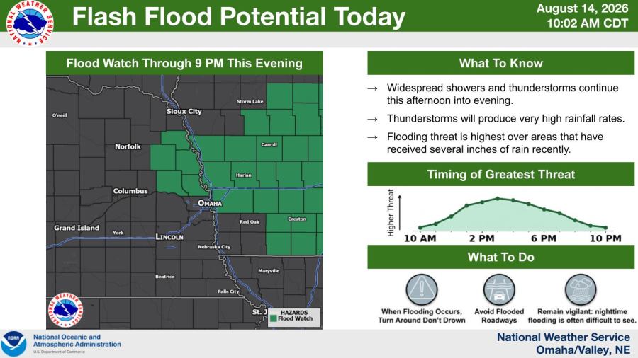
National Weather Service map showing five eastern Nebraska counties under a flood watch until 9 p.m.
Updated Aug. 14, 2026.
Burt, Cuming, Dodge, Thurston and Washington counties could receive rainfall capable of causing flash flooding Friday afternoon and evening.
Five eastern Nebraska counties are under a flood watch until 9 p.m. Friday, Aug. 14, as additional storms could bring heavy rain to areas where the ground is already saturated.
The watch covers Burt, Cuming, Dodge, Thurston and Washington counties. Communities within the affected area include Fremont, Blair, Tekamah, West Point, Wisner, Pender, Winnebago, Walthill, Macy, Lyons, Oakland and Decatur.
Omaha and Douglas County are not included in the watch. The affected area also extends into western Iowa, covering Harrison, Monona, Pottawattamie and Shelby counties, including Council Bluffs.
Rain could fall at rates of 2 to 3 inches per hour
Thunderstorms could produce rainfall rates of 2 to 3 inches per hour at times during the afternoon and evening. The intensity and total rainfall will vary among the communities covered by the watch.
The greatest threat is in locations that have already received heavy rain over the past three days. Additional rainfall in those areas could quickly run off into streets, low-lying land, creeks and rivers.
Excessive runoff could cause extensive street flooding and rapidly raise water levels in creeks, streams and other flood-prone locations. The placement of the heaviest rainfall will depend on how the storms develop and move during the afternoon.
Fremont and Blair are included, while Omaha remains outside the watch
Dodge County, which includes Fremont, and Washington County, home to Blair, are within the watch area. Burt County includes communities such as Tekamah and Oakland, while Cuming County includes West Point and Wisner.
In Thurston County, the watch covers Pender, Winnebago, Walthill and Macy. The affected area continues east of the Missouri River into Council Bluffs and other western Iowa communities.
Douglas County was not included in the watch issued Friday morning. Although Omaha could receive rain or thunderstorms during the day, the city is outside the specific area covered by this flood watch.
The region has experienced several rounds of severe weather this summer. On July 30, storms carrying damaging winds and heavy rain crossed eastern Nebraska and western Iowa, creating a risk of localized flash flooding.
The flood watch is scheduled to end at 9 p.m.
A flood watch means conditions could produce flooding, but it does not indicate that every included city already has flooded streets, roads or homes.
A flash flood warning carries greater urgency. It applies to a more specific area when rapidly rising water has been detected or flooding is imminent. The National Weather Service could issue additional warnings if storms repeatedly produce heavy rain over the same locations.
The complete list of counties and any changes to the expiration time are available in the current National Weather Service Omaha/Valley flood watch.
The watch is scheduled to expire at 9 p.m. Friday, Central Time. The National Weather Service may extend, reduce or cancel it before then if conditions change.
Stay informed about what’s happening in your community. Your source for stories that inspire — visit HolaNebraska.org for news, culture and community updates across Nebraska.